Awarta
| ||
 | ||
| Państwo | / | |
|---|---|---|
| Muhafaza | Nablus | |
| Populacja (2016) • liczba ludności | 6824 | |
| Kod pocztowy | 464 | |
| 32°09′41″N 35°17′11″E/32,161444 35,286392 | ||
Awarta – wieś w Palestynie, w muhafazie Nablus. Według danych Palestyńskiego Centralnego Biura Statystycznego w 2016 roku liczyła 6824 mieszkańców[1].
Przypisy
- ↑ Localities in Nablus Governorate by Type of Locality and Population Estimates, 2007–2016 (ang.). Palestinian Central Bureau of Statistics.
Media użyte na tej stronie
Flag of Israel.svg
Flag of Israel. Shows a Magen David (“Shield of David”) between two stripes. The Shield of David is a traditional Jewish symbol. The stripes symbolize a Jewish prayer shawl (tallit).
Flag of Israel. Shows a Magen David (“Shield of David”) between two stripes. The Shield of David is a traditional Jewish symbol. The stripes symbolize a Jewish prayer shawl (tallit).
13.03.11.P3130560.JPG
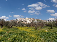
Awarta, Palestine
Awarta, Palestine
Governate of Nablus.png
Map of the Palestinian Authorities showing the Governate of Nablus
Map of the Palestinian Authorities showing the Governate of Nablus
West Bank and Gaza Strip location map.svg
Autor: NordNordWest, Licencja: CC BY-SA 3.0
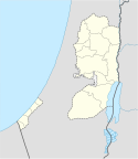
Location map of the Palestinian territories (West Bank and Gaza Strip)
Autor: NordNordWest, Licencja: CC BY-SA 3.0
Location map of the Palestinian territories (West Bank and Gaza Strip)


