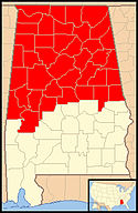
Diecezja Birmingham w Alabamie
 Katedra diecezjalna św. Pawła | |
| Państwo | |
|---|---|
| Siedziba | Birmingham |
| Data powołania | |
| Wyznanie | |
| Kościół | |
| Metropolia | Mobile |
| Katedra diecezjalna | Katedra św. Pawła w Alabamie |
| Biskup diecezjalny | bp Steven Raica |
| Biskup senior | |
| Dane statystyczne (2006) | |
| Liczba wiernych • odsetek wiernych | 98 600 |
| Liczba kapłanów • w tym diecezjalnych • w tym zakonnych | 96 |
| Liczba osób zakonnych | 182 |
| Liczba parafii | 55 |
| Powierzchnia | 72 728 km² |
| Strona internetowa | |
Diecezja Birmingham w Alabamie (łac. Dioecesis Birminghamiensis, ang. Diocese of Birmingham in Alabama) jest diecezją Kościoła rzymskokatolickiego w północnej części stanu Alabama.
Historia
Diecezja została kanonicznie erygowana 28 czerwca 1969 roku przez papieża Pawła VI. Wyodrębniono ją z terenów ówczesnej diecezji Mobile-Birmingham. Pierwszym ordynariuszem został dotychczasowy biskup pomocniczy diecezji Mobile-Birmingham Joseph Gregory Vath (1918-1987). Kościół, który stał się w 1969 roku katedrą diecezjalną, wybudowano w roku 1893.
Ordynariusze
- Joseph Gregory Vath (1969-1987)
- Raymond Boland (1988-1993)
- David Foley (1994-2005)
- Robert Joseph Baker (2005–2020)
- Steven Raica (od 2020)
Media
Na terenie diecezji ma swą siedzibę EWTN - katolicka telewizja, którą oglądać można również w Europie.
Bibliografia
- Oficjalna strona internetowa diecezji Birmingham (ang.)
- Diecezja Birmingham w Alabamie w bazie catholic-hierarchy.org (ang.)
Media użyte na tej stronie
Autor: Uwe Dedering, Licencja: CC BY-SA 3.0
Location map of the USA (without Hawaii and Alaska).
EquiDistantConicProjection:
Central parallel:
* N: 37.0° N
Central meridian:
* E: 96.0° W
Standard parallels:
* 1: 32.0° N
* 2: 42.0° N
Made with Natural Earth. Free vector and raster map data @ naturalearthdata.com.
Formulas for x and y:
x = 50.0 + 124.03149777329222 * ((1.9694462586094064-({{{2}}}* pi / 180))
      * sin(0.6010514667026994 * ({{{3}}} + 96) * pi / 180))
y = 50.0 + 1.6155950752393982 * 124.03149777329222 * 0.02613325650382181
      - 1.6155950752393982  * 124.03149777329222 *
     (1.3236744353715044  - (1.9694462586094064-({{{2}}}* pi / 180))
      * cos(0.6010514667026994 * ({{{3}}} + 96) * pi / 180))
The flag of Navassa Island is simply the United States flag. It does not have a "local" flag or "unofficial" flag; it is an uninhabited island. The version with a profile view was based on Flags of the World and as a fictional design has no status warranting a place on any Wiki. It was made up by a random person with no connection to the island, it has never flown on the island, and it has never received any sort of recognition or validation by any authority. The person quoted on that page has no authority to bestow a flag, "unofficial" or otherwise, on the island.
Japanese map symbol "Church". U+26EA
Autor: Alexrk2, Licencja: CC BY 3.0
Ta mapa została stworzona za pomocą GeoTools.
Autor: Gaagaagiw, Licencja: CC BY 3.0
The Cathedral of St. Paul viewed from the southeast.
Autor: Croberto68, Licencja: CC BY-SA 3.0
Map of the Catholic diocese of Birmingham in the USA.


