Via Labicana
Autor:
Credit:
it:Utente:EH101
Based on a map from "Historical Atlas" by William R. Shepherd, New York, Henry Holt and Company, 1923 now in Public Domain.
Reference: Territorial Expansion of Rome [p.34-35] [1926 ed.] Inset: Vicinity of Rome.
Courtesy of the University of Texas Libraries, The University of Texas at Austin.
[1]![[1]](http://www.lib.utexas.edu/maps/historical/shepherd/rome_expansion.jpg)
Krótki link:
źródło:
Wymiary:
451 x 257 Pixel (60016 Bytes)
Opis:
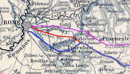
Ancient roman Labicana way (red color). In the picture are also higlighted the Latina way(blue) and the Prenestina way (violet)
Licencja:
Komentarz do licencji:
EH101 z it.wikipedia.org – właściciel praw autorskich do tego dzieła, udostępnia je na poniższej licencji
Warunki licencji:
Creative Commons Attribution-Share Alike 3.0
Więcej informacji o licencji można znaleźć tutaj. Ostatnia aktualizacja: Mon, 17 May 2021 18:03:54 GMT