Bounty (wyspy)
| ||
 Panorama wysp z Proclamation Island, z licznymi ptakami morskimi | ||
| Państwo | ||
| Akwen | Ocean Spokojny | |
| Wyspy | Depot Island, Penguin Island, Ruatara Island | |
| Liczba wysp | 13 | |
| Powierzchnia | 1,35 km² | |
| Populacja • liczba ludności | bezludne | |
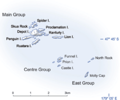
Mapa | ||
Bounty Islands – grupa 13 granitowych wysepek położonych na Pacyfiku, na południowy wschód od Wyspy Południowej Nowej Zelandii. Należą do państwa Nowej Zelandii, są niezamieszkane. W 1788 roku odkrył je William Bligh.
Lista wysp
- Grupa Główna
- Depot Island (największa)
- Lion Island
- Penguin Island
- Proclamation Island
- Ranfurly Island
- Ruatara Island
- Spider Island
- Tunnel Island
- Grupa Środkowa
- Castle Island
- Funnel Island
- Prion Island
- Grupa Wschodnia
- Molly Cap
- North Rock
Media użyte na tej stronie
Flag of New Zealand. Specification: http://www.mch.govt.nz/nzflag/description.html , quoting New Zealand Gazette, 27 June 1902.
Autor:
- New_Zealand_location_map.svg: NordNordWest
- derivative work: Виктор В (talk)
Location map of New Zealand
Autor: New Zealand's Department of Conservation, Licencja: CC BY 3.0 nz
Mapa nowozelandzkich wysp Bounty
Shiny LightSteelBlue button/marker widget. Used to mark the location of something such as a tourist attraction.
Autor: Lawrie Mead, Licencja: CC BY-SA 4.0
From Proclamation Island - looking South East. Depot island is on the right, Lion Island is on the far left foreground with Ranfurly to the right. North Rock, Molly Cap and Funnel Island in the distance from left to right.


