East New York
| Ten artykuł od 2014-04 wymaga zweryfikowania podanych informacji. |
| Dzielnica (neighborhood) Nowego Jorku | |
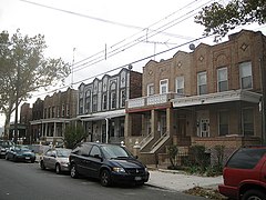
 Typowe domy bliźniaki typu rowhouse na East New York | |
| Państwo | |
|---|---|
| Stan | |
| Miasto | Nowy Jork |
| Dzielnica | Brooklyn |
| Powierzchnia | 4,84 km² |
| Populacja (16,000) • liczba ludności | 79,602 |
| Kod pocztowy | 11207, 11208, 11239 |
Położenie na mapie stanu Nowy Jork (c) NordNordWest, CC BY 3.0 | |
| 40°40′00″N 73°52′56″W/40,666667 -73,882222 | |
| Portal | |
East New York - wschodnia dzielnica (neighborhood) Brooklynu, okręgu Nowego Jorku. East New York jest zamieszkiwany przez Afroamerykanów i Latynosów.
Znane osoby z ENY
- Tony Danza - aktor
- Masta Killa - raper, członek Wu-Tang Clan
- AZ - raper
- Uncle Murda - raper
- John Brockington - piłkarz
- Lil' Mama - raper
- Martín Espada - poeta
- Jeru the Damaja - raper
Linki zewnętrzne
Media użyte na tej stronie
Autor: Alexrk2, Licencja: CC BY 3.0
Ta mapa została stworzona za pomocą GeoTools.
Autor: Uwe Dedering, Licencja: CC BY-SA 3.0
Location map of the USA (without Hawaii and Alaska).
EquiDistantConicProjection:
Central parallel:
* N: 37.0° N
Central meridian:
* E: 96.0° W
Standard parallels:
* 1: 32.0° N
* 2: 42.0° N
Made with Natural Earth. Free vector and raster map data @ naturalearthdata.com.
Formulas for x and y:
x = 50.0 + 124.03149777329222 * ((1.9694462586094064-({{{2}}}* pi / 180))
      * sin(0.6010514667026994 * ({{{3}}} + 96) * pi / 180))
y = 50.0 + 1.6155950752393982 * 124.03149777329222 * 0.02613325650382181
      - 1.6155950752393982  * 124.03149777329222 *
     (1.3236744353715044  - (1.9694462586094064-({{{2}}}* pi / 180))
      * cos(0.6010514667026994 * ({{{3}}} + 96) * pi / 180))
(c) NordNordWest, CC BY 3.0
Location map of the State of New York, USA
The flag of Navassa Island is simply the United States flag. It does not have a "local" flag or "unofficial" flag; it is an uninhabited island. The version with a profile view was based on Flags of the World and as a fictional design has no status warranting a place on any Wiki. It was made up by a random person with no connection to the island, it has never flown on the island, and it has never received any sort of recognition or validation by any authority. The person quoted on that page has no authority to bestow a flag, "unofficial" or otherwise, on the island.
Seal of New York City, as portrayed by Paul Manship’s standardized version.
The seal’s 1.1:1 height-to-width ratio is intentional and representative Manship’s original model. The one departure in this rendering from the original is the use of beavers based on the 1623 seal of the Province of New Netherland in order to portray them in greater detail. Since Manship’s original was a sculpture rather than a print, there are no official standards for the seal colors. The version shown here represents the contributor's attempt to use as many historically accurate hues as possible. Including accounts of traditional Lenape dress, and 15th/16th century Dutch uniforms. The red, white, and blue of the wreath are taken from the battle flag of the Fifth New York Regiment of the Civil War, which depicts the arms of the City.
Looking southeast at 75th Precinct at 1000 Sutter Avenue in ENY on a sunny springtime afternoon.
Autor: MMZach, Licencja: CC BY-SA 3.0
Semi-detached rowhouses on a street in East New York, Brooklyn.
(c) Postdlf, CC-BY-SA-3.0
The Brooklyn Bridge, seen from Manhattan, New York City.


