Évisa
| gmina | |||
| |||
| Państwo | |||
|---|---|---|---|
| Region | |||
| Departament | |||
| Okręg | |||
| Kod INSEE | 2A108 | ||
| Powierzchnia | 64,25 km² | ||
| Populacja (1990) • liczba ludności |
| ||
| • gęstość | 4 os./km² | ||
| Portal | |||
Evisa (kors. Èvisa) – miejscowość i gmina we Francji, w regionie Korsyka, w departamencie Korsyka Południowa.
Według danych na rok 1990 gminę zamieszkiwało 257 osób, a gęstość zaludnienia wynosiła 4 osób/km².
Linki zewnętrzne
- Źródło danych: Francuski urząd statystyczny. (fr.).
Media użyte na tej stronie
Autor: Eric Gaba (Sting - fr:Sting), Licencja: CC BY-SA 3.0
Blank administrative map of the department of Corse-du-Sud, France, for geo-location purpose, with distinct boundaries for departments and arrondissements.
Autor: Superbenjamin, Licencja: CC BY-SA 4.0
Blank administrative map of France for geo-location purpose, with regions and departements distinguished. Approximate scale : 1:3,000,000
Autor: Eric Gaba (Sting - fr:Sting), Licencja: CC BY-SA 3.0
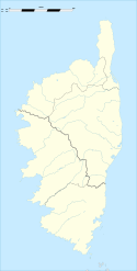
Blank administrative map of the region of Corsica, France, for geo-location purpose, with distinct boundaries for departments and arrondissements as they are since January 2010.
The former version of the map shows the boundaries as they were until December 2009.
(c) Photo: Myrabella / Wikimedia Commons, CC BY-SA 3.0
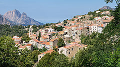
Évisa, Southern Corsica, France. In the left background, Capu d'Ortu e Tre Signore.
Autor: Tretinville, Licencja: CC BY-SA 3.0
Écartelé : au premier de gueules aux monts d'argent surmontés d'une aigle volante du même, au deuxième d’azur au sapin arraché d’or, au troisième d’azur au mouflon sautant d’or, au quatrième de gueules au château crénelé d'argent.


