Mount Buller
 | |
| Państwo | |
|---|---|
| Stan | |
| Położenie | |
| Pasmo | |
| Wysokość | 1805 m n.p.m. |
| Pierwsze wejście | nieznany |
Położenie na mapie Wiktorii  | |
Położenie na mapie Australii  | |
Mount Buller – góra w Alpach Australijskich w stanie Wiktoria (wysokość 1805 m n.p.m.), ok. 150 km (w linii prostej) na północny wschód od Melbourne. Na zboczach góry położona jest miejscowość Mount Buller, będąca popularnym w Melbourne ośrodkiem narciarskim w sezonie zimowym (lipiec, sierpień).
Galeria
 (c) I, Stevage, CC-BY-SA-3.0
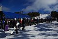 (c) I, Stevage, CC-BY-SA-3.0
Linki zewnętrzne
Media użyte na tej stronie

.svg)
Flag of Victoria (Australia).svg
State flag and government ensign (internal waters only) of Victoria.

State flag and government ensign (internal waters only) of Victoria.

U+25B2.svg
Black up-pointing triangle ▲, U+25B2 from Unicode-Block Geometric Shapes (25A0–25FF)
Black up-pointing triangle ▲, U+25B2 from Unicode-Block Geometric Shapes (25A0–25FF)
Australia relief map.jpg
Autor: , Licencja: CC BY-SA 3.0
Relief map of Australia, including the borders of the states of the Commonwealth of Australia
Autor: , Licencja: CC BY-SA 3.0
Relief map of Australia, including the borders of the states of the Commonwealth of Australia
Australia Victoria relief location map.jpg
Autor:
Location map of Victoria, Australia
Autor:
- Australia_Victoria_location_map.svg: NordNordWest
- derivative work: Uwe Dedering (talk)
Location map of Victoria, Australia

Mt Buller Bourke St Stevage.jpg
(c) I, Stevage, CC-BY-SA-3.0
The Blue Bullet 1 chair lift at the bottom of Bourke St, at Mount Buller.
(c) I, Stevage, CC-BY-SA-3.0
The Blue Bullet 1 chair lift at the bottom of Bourke St, at Mount Buller.

Mt Buller village Stevage.jpg
(c) I, Stevage, CC-BY-SA-3.0
A view over the central part of the Mt Buller village]].
(c) I, Stevage, CC-BY-SA-3.0
A view over the central part of the Mt Buller village]].
Mount-buller-summit-ridge.jpg
Autor: Alex Cohen, Licencja: CC-BY-SA-3.0
Mount Buller summit ridge in Summer from the Northwest.
Autor: Alex Cohen, Licencja: CC-BY-SA-3.0
Mount Buller summit ridge in Summer from the Northwest.