Beverley
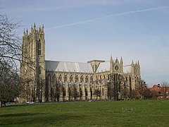
(c) Philip Pankhurst, CC BY-SA 2.0 Beverley Minster | |||
| |||
| Państwo | |||
|---|---|---|---|
| Kraj | |||
| Region | |||
| Hrabstwo ceremonialne | |||
| Unitary authority | |||
| Populacja (2011) • liczba ludności |
| ||
| Nr kierunkowy | 01482 | ||
| Kod pocztowy | HU17 | ||
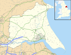
Położenie na mapie East Riding of Yorkshire Contains Ordnance Survey data © Crown copyright and database right, CC BY-SA 3.0 | |||
Położenie na mapie Wielkiej Brytanii (c) Karte: NordNordWest, Lizenz: Creative Commons by-sa-3.0 de | |||
| Strona internetowa | |||
| Portal | |||
Beverley – miasto i civil parish w północno-wschodniej Anglii (Wielka Brytania), w hrabstwie ceremonialnym East Riding of Yorkshire, ośrodek administracyjny dystryktu (unitary authority) East Riding of Yorkshire[1], położone na zachodnim brzegu rzeki Hull. W 2011 roku civil parish liczyła 18 624 mieszkańców[2]. Beverley zostało wspomniane w Domesday Book (1086) jako Beureli[3].
Urodzeni w Beverley
- Katie O’Brien - brytyjska tenisistka
- Elizabeth Simmonds - brytyjska pływaczka
Miasta partnerskie
Przypisy
- ↑ Ordnance Survey linked data
- ↑ Neighbourhood Statistics. neighbourhood.statistics.gov.uk. [zarchiwizowane z tego adresu (2016-10-11)]..
- ↑ The Domesday Book online.
Media użyte na tej stronie
(c) Karte: NordNordWest, Lizenz: Creative Commons by-sa-3.0 de
Location map of the United Kingdom
Flag of England. Saint George's cross (a red cross on a white background), used as the Flag of England, the Italian city of Genoa and various other places.
The flag of Navassa Island is simply the United States flag. It does not have a "local" flag or "unofficial" flag; it is an uninhabited island. The version with a profile view was based on Flags of the World and as a fictional design has no status warranting a place on any Wiki. It was made up by a random person with no connection to the island, it has never flown on the island, and it has never received any sort of recognition or validation by any authority. The person quoted on that page has no authority to bestow a flag, "unofficial" or otherwise, on the island.
(c) David Wright, CC BY-SA 2.0
Coat of arms of the borough of Beverley: Argent, three bars wavy Azure; on a chief Azure, a beaver with its head turned and biting at its fur, Or. The Sign of The Beverley Arms, Beverley, East Riding of Yorkshire, England.
The Beverley Arms TA0339 : The Beverley Arms, 25 North Bar Within is situated at 25 North Bar Within.
(c) Philip Pankhurst, CC BY-SA 2.0
Beverley Minster, Beverley in the East Riding of Yorkshire, England.
Contains Ordnance Survey data © Crown copyright and database right, CC BY-SA 3.0
Map of the East Riding of Yorkshire, UK with the following information shown:
- Administrative borders
- Coastline, lakes and rivers
- Roads and railways
- Urban areas
Equirectangular map projection on WGS 84 datum, with N/S stretched 165%
Geographic limits:
- West: 1.11W
- East: 0.25E
- North: 54.20N
- South: 53.56N


