Kanał Odra-Dunaj-Łaba

Kanał Odra – Dunaj – Łaba, oficjalna nazwa Wodny korytarz Dunaj – Odra – Łaba – planowany kanał wodny mający połączyć rzeki Odrę, Dunaj i Łabę. Ma mieć około 550 km i przebiegać przez trzy państwa – Polskę, Czechy oraz Austrię lub Słowację.
Wodny korytarz w ciągu Odra – Dunaj ma się rozpoczynać w okolicach Gliwic, gdzie będzie się łączył z kanałem Gliwickim, a kończyć w okolicach Wiednia lub Bratysławy. W rejonie Przerowa ma odchodzić nitka prowadząca do Łaby. Koncepcja budowy wodnego korytarza Odra – Dunaj – Łaba bądź Odra – Dunaj istnieje już od lat[1], dotąd jednak nie udało się doprowadzić do jej realizacji[2]. W 2010 r. wzmożono wysiłki zwłaszcza czeskich władz zmierzające ku budowie[3][4].
Budowa wodnego korytarza D–O–L ma być ogromnym przedsięwzięciem. Szacuje się, że jej koszty wyniosą 8 mld euro. Ewentualna dotacja mogłaby wynieść nawet do 80–90% kosztów realizacji całej inwestycji[5].

Ujście Morawy do Dunaju w Bratysławie, możliwy początek D-O-L
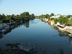
Kanał Odra – Dunaj niedaleko Wiednia wybudowany w latach 1939–1943
Kanał Odra – Dunaj niedaleko Wiednia wybudowany w latach 1939–1943

Kanał Odra – Dunaj w Wiedniu (w dzielnicy Donaustadt) wybudowany w latach 1939–1943. Możliwy do wykorzystania jako fragment D-O-L

Początek Kanału Gliwickiego na Odrze w Kędzierzynie-Koźlu

Miejsce połączenia Kanału Gliwickiego z Kanałem Kędzierzyńskim. Początek kanału Odra – Dunaj wybudowanego w latach 1939–1943

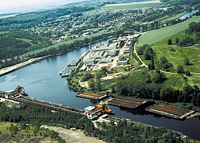
Koniec Kanału Kędzierzyńskiego wybudowanego w latach 1939–1970. Pierwotnie część kanału Odra – Dunaj

Kanał Ulga w Raciborzu, planowany fragment D-O-L
Port w Chvaleticach, ostatni port na Łabie

Mapa wariantów kanału
Przypisy
- ↑ Koncepcję tę chciał realizować m.in. Adolf Hitler – zob. Stefan Dejkało (red.), Rozmowy przy stole, Warszawa: Charyzma, 1996, s. 76, 376, ISBN 83-85820-02-07.
- ↑ History of Danube-Oder-Elbe waterway, D–O–L [dostęp 2010-07-21] [zarchiwizowane z adresu 2013-03-31] (ang.).
- ↑ Bartłomiej Kuraś, Czeski kanał Odra – Dunaj – Łaba, Wyborcza.pl, 14 listopada 2009 [dostęp 2010-07-21] [zarchiwizowane z adresu 2009-11-15].
- ↑ Aleksander Król: Gminom bardziej zależy na kanale niż państwu. Dziennik Zachodni, 15 marca 2010. [dostęp 2010-07-21]. (pol.).
- ↑ Aleksander Król: Czesi będą mieli dostęp do morza. Dziennik Zachodni, 16 stycznia 2010. [dostęp 2010-07-21]. (pol.).
Linki zewnętrzne
- Strona wodnego korytarza Dunaj-Odra-Łaba (cz. • pol. • ang. • niem.)
- Forum poświęcone budowie wodnego korytarza D-O-L
Media użyte na tej stronie

Autor: Jaroslav Kubec, Licencja: CC BY 3.0
The site of the Morava influx into the Danube under the ruins of Devín. The water corridor D-O-E would branch-off here in case of the variant A or D.

Autor: Jaroslav Kubec, Licencja: CC BY 3.0
A flood diversion canal of the Oder cirkling arround Racibórz. Built for navigation also.

Autor: Jaroslav Kubec, Licencja: CC BY-SA 3.0
At this place was grounbreaking for the Oder-Danube Canal on December 8, 1939 near Nowa Wieś close to Kędzierzyn. From left to right is Gliwice canal with a wide mouth of a 6-km stretch of Oder-Danube Canal - a branch canal for the chemical factory in Kędzierzyn.

Autor: Jaroslav Kubec, Licencja: CC BY 3.0
A view of the branching-off place of the water corridor D-O-E at Lobau (var. B and C). At the front, the main bed of the Danube; behind, a recently established floodway; at the back, some kilometers long wrking section of the D-O-E canal (right flowing into the port of Lobau (left).

Autor: Tomáš Kolařík, Licencja: CC BY-SA 3.0
Completed part of canal Donau - Oder near Vienna

Autor: Plavba a vodní cesty o.p.s., Licencja: CC BY-SA 4.0
The map of varinats of Danube Oder Elbe canal

Autor: Jaroslav Kubec, Licencja: CC BY 3.0
The port of Kózle. The picture shows the mouth of the Gliwice Canal disappearing in the bank line. Behind, on the right, the lock of Kozlí on the Oder.

Autor: Invisigoth67, Licencja: CC BY-SA 3.0
Donau-Oder-Kanal in Wien Donaustadt, Bereich Lobaustraße
Karte der Wasserstrassen Deutschlands
für Schiffe von 100 und mehr Tonnen Tragfähigkeit
sowie der
von Österreich geplanten Wasserstrassen
von der Elbe, Oder und Weichsel zur Donau.
Karte (Blatt II) aus
Denkschrift zu dem technischen Entwurf einer neuen Donau-Main-Wasserstrasse von Kelheim nach Aschaffenburg,
bearbeitet von Eduard Faber [(† 1930)],
kgl. Bauamtmann und Vorstand des technischen Amtes
des Vereines für Hebung der Fluss- und Kanalschiffahrt in Bayern.
Verlegt
von dem Vereine für Hebung der Fluss- und Kanalschiffahrt in Bayern.
1903.

Autor: Josef Podzimek, Licencja: CC BY-SA 3.0
Port Chvaletice is last port on the river Elbe. Navigability of Elbe should be extended to Pardubice and then to water corridor D-O-E.

Autor: Tomáš Kolařík, Licencja: CC BY-SA 3.0
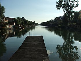
Another completed part of Donau - Oder canal

Autor: Jaroslav Kubec, Licencja: CC BY 3.0
A terminal port of the Kedzierzyn canal, complete part of Donau-Oder canal built in 1938-1943.